
GIS Projects
Northeast US Salt Marsh Tax Parcel Blue Carbon Viewer
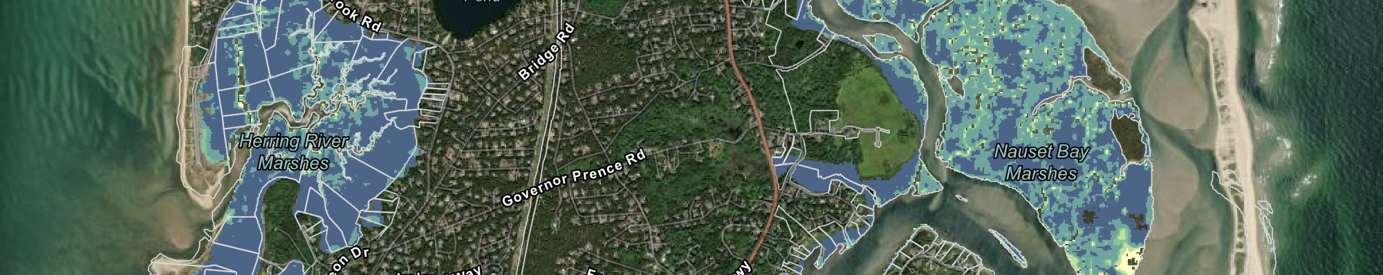
This ArcGIS Experience Builder application, which I completed for Massachusetts State Geologist Brian Yellen, presents an estimated carbon sequestration rate for over 40,000 individual tax parcels containing salt marsh from New York to Maine. To create this application, I executed spatial analysis with many raster and vector layers in ArcGIS Pro and shared the final layers to ArcGIS Online. Gathering the relevant parcel shapefiles required communicating with over twenty municipalities across the region. Alongside Dr. Yellen, I also composed documentation to communicate project details to a public audience.
I originally completed a version of this project which covered just Massachusetts as a Graduate Research Assistant, and one of my tasks in my subsequent internship in Summer 2025 was to expand it to other states.
Access the ArcGIS Experience at this link.
Python Script to Download MassGIS DEM Tiles
As the Geospatial Intern at the Massachusetts Geological Survey in Summer 2025, I was tasked with obtaining, analyzing, and presenting environmental information for thousands of long-term ecological research plots located in forests across the state. One task which I completed as part of this process is downloading and managing approximately 1500 digital elevation model (DEM) tiles using a script in a Python Notebook. This script eliminated the need for manual downloading, which would be infeasible given the number of tiles needed, and enabled me to analyze the slope, aspect, and curvature of each 1/5 acre plot.
Read below or view in a separate tab.
Species Distribution Modeling for an Invasive Plant
For the UMass Amherst course Spatial Data Analysis in R, I completed a current and future species distribution model for the plant species tree-of-heaven, which is considered invasive in Massachusetts. In this Spring 2025 project, I explored my interest in mapping invasive plants, which I recognize as being important targets for land management agencies. I was excited to include methods to download necessary data directly to the project to alleviate the need to manually navigate to websites whenever updated data may be required in the future.
Read below or view in a separate tab.
API-Driven Species Mapping Dashboard using FME
For the UMass Amherst course Spatial Databases and Data Interoperability, I used Feature Manipulation Engine (FME) to query the API of the Global Biodiversity Information Facility and create an ArcGIS Dashboard to display species occurrence points alongside particular habitat polygons. This was the final project for this Fall 2024 course. This project was intended to improve the workflow for creating similar maps, which formed part of my work in a Middlebury College course (see section Small Mammal Species Range Dashboard).
Access the slide deck for my project presentation, which provides context for the Dashboard, at this link.
Access the ArcGIS Dashboard at this link.
International Association for the Study of the Commons Web Map
As a project for Dr. Charles Schweik, a UMass Amherst professor, I developed a web application to help people navigate during the International Association for the Study of the Commons 20th Biennial Conference, an event held on campus in June 2025. Creating the app involved georeferencing floor plans of campus buildings at which conference presentations were held within ArcGIS Pro. Throughout the conference, which attracted hundreds of attendees from across the world, my application served as the navigational tool for newcomers to campus.
Access the web application below or at this link.
Access the conference’s “Information for In-Person Participants” page, which advertises my application, at this link.
Tanzania Wildlife Corridor Reproduction Study
I completed the following project with a classmate in the Middlebury College course Open GIScience during the Fall 2023 semester. Using the software R, we attempted to reproduce the steps of a QGIS model which produced a least cost surface for an area in Tanzania. We used packages such as stars, raster, and tmap to create an analogous workflow to that of the QGIS model. I provided CRediT roles to reflect the balance of work between the two contributors at the conclusion of the report linked below.
Access the published Open Science Framework page, created by instructor Dr. Joseph Holler to detail the project, at this link.
Access my version of the report for the project below or at this link.
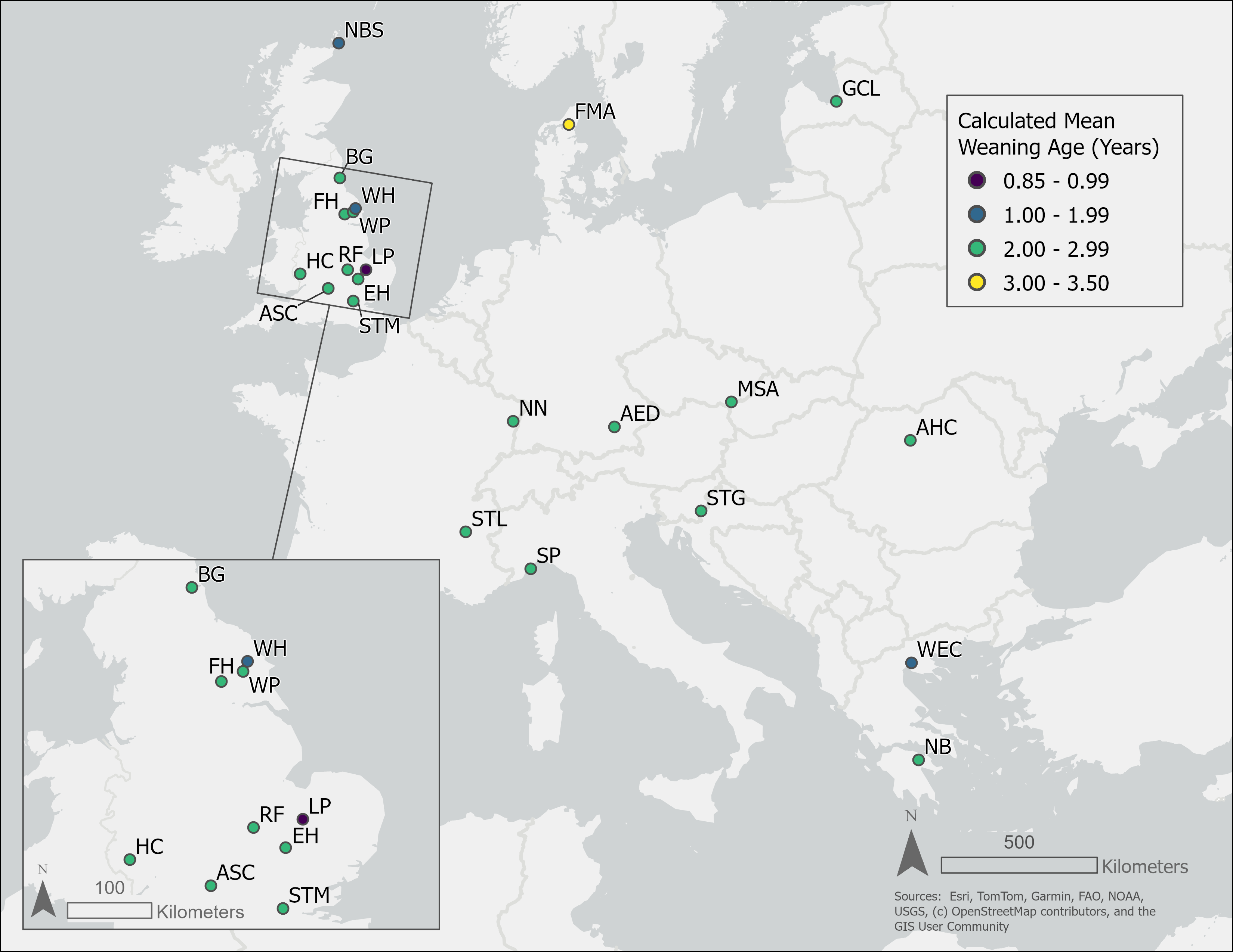
Publication-Quality Map of Europe for Academic Journal
In July 2025, I created a map of European cemeteries for UMass Anthropology PhD student Claire L. Gold for use in a recent submission to the American Journal of Human Biology. I was delighted to contribute by creating and refining the map using ArcGIS Pro, and I also ensured that my exported map conformed to the image standards set by the journal.
View the map below:
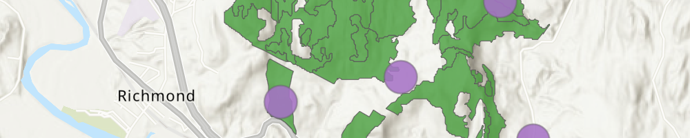
Vermont Small Mammal Species Range Dashboard
For the capstone requirement for the Environmental Studies major at Middlebury College, I was part of a four-person group to assist the Vermont Fish & Wildlife Department in gathering information on small mammals and mesocarnivores for the upcoming 2025 update to the state Wildlife Action Plan. Within my group, I was personally responsible for the creation of 17 public-facing ArcGIS web maps. Each web map displays data on one mammal species from the Global Biodiversity Information Facility and, where applicable, the natural history collections at the University of Vermont. From personal communication with instructor Dr. Alexis Mychajliw, the Mammal Scientific Adivsory Group subsequently used the maps to help update the mammal sections in the forthcoming Wildlife Action Plan update.
Access the ArcGIS Dashboard at this link. Note that the first map may initially take time to load – the user can expedite loading by zooming into the map element (the large rectangle, if it is not loading) and waiting for a short period of time.
Google Earth Engine Forested Habitat Block Report
I composed this report for the Middlebury College course Conservation Planning in Spring 2023. It involves adding to a forested habitat block model created by instructor Dr. Jeff Howarth to allow for natural communities, a classification system for habitat types administered by the state of Vermont, to be captured in the model. I composed this report with the intent for the methodology to be accessible to those without prior experience with GIS. I used Google Earth Engine and WhiteboxTools to achieve the results.
Read below or view in a separate tab.
UMass Campus Topographic Map Replication
In February 2025, I took on a project to update a topographic map of the UMass Amherst campus for use in the class materials of an introductory Geology course. The professor provided me with a map printed on physical media with no online sources. I used LiDAR, road, and building data within ArcGIS Pro to replicate the extent and style of the reference map while ensuring that contour line features reflected more current topography. The professor, Dr. William Clement, has added the map to his class materials for the Fall 2025 semester.
View the updated map (first page) and the reference map (second page) below or view in a separate tab.
Green Needham “Tap Map”
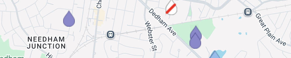
In August and September of 2024, I created a web map showing the locations of water fountains and water bottle filling stations in Needham, Massachusetts for the community environmental organization Green Needham. To construct the map, I collected coordinates of water fountains both outdoors and inside public buildings. I then used the WordPress plugin WP Go Maps to create point data.
Access the map at this link.
Access a blog post published by Green Needham to advertise the map at this link.